Friday Middle at Frenchman Coulee
March 22, 2024
8:00am - 4:00pm Frenchman Spring Model Course Open
11:00am - 2:00pm Packet Pickup Available at the Event Center
12:00pm - 2:30pm Starts Open. You must be in the start area ready to race 8 minutes before your start time. See your start time on EventReg
4:30pm Courses Close (2hr time limit)
Map Information
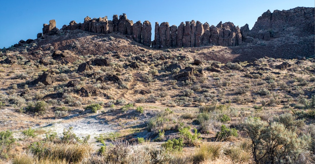
Frenchman Coulee terrain is composed mostly of a relatively flat sagebrush covered plain bordered by rolling hills to the south. Bisecting the plain are Pleistocene aged flood channels carved into underlying basalt formations. Running the length of the channel are shale slopes and cliffs. The presence of these long linear features interspersed with shale slopes makes for challenging route finding while crossing the plain. Located within the limits of these channels are ponds, marshes and small waterways. The wet areas of Frenchman are often lined with dense vegetation creating a challenging traverse. Within the limits of the map are other navigable linear features in the form of old fence lines, creek beds, distinct reentrants and spurs. Point features consist of old equipment, knolls, hilltops and depressions.
- Trails are becoming less distinct – With the banning of cattle ranching within the venue footprint, the trails have become increasingly less visible. In addition, with the early onset of spring, new grass shoots can mask already obscure trail locations.
- Cliffs – Not all cliff locations are depicted on the map. Feature density has resulted in the exclusion of some smaller cliffs. In areas with multiple cliff bands, rely on the more prominent cliffs for navigation. In addition, not all cliffs are vertical for their entire height. The top and bottom of some cliffs may be rounded and less distinct. Most cliffs on the course range from 1.5m to 4m in height. The White, Yellow, and Orange courses have been routed away from the larger cliffs. No attempt should be made to navigate over cliffs marked “Uncrossable”.
- Bare Rock – Only uniform and vegetation-free rock slabs have been marked as bare rock. As a result, very little of the apparent rocky surfaces at the Frenchman venue meet the criteria of bare rock. Most areas devoid of vegetation consist of decomposed “rotten” rock or fractured basalt flows interspersed with vegetation. These areas have been mapped as rough open or stony ground.
- Water Crossings – Orange courses and above may cross seasonal streams. These water crossings can have higher flows during the spring months. If flow rates are high, you may get your feet wet at a stream crossing. All streams are safe to cross even at the highest flows.
- Knolls – A uniform body of many smaller rocks, broken rocky surface or a proper dirt knoll.
- Boulders – Most rocky outcroppings and mounds are marked as knolls. Only singular distinct rocks will be mapped as boulders. Generally, mapped boulder sizes are: Small 1m-2m, Medium 2m-3.m:and Large 3m+
- Man made features – rolls of barbed wire, old fence posts.
- Vegetation – Sage bush mostly, some trees and larger bushes near water bodies.
Download a map of the area used at a previous event: Frenchman Coulee - Letter
Reminder that the map shows embargoed areas, and that possession of the map does not imply permission to enter.
Course Notes
Course Designer: Chris Cooper
Safety bearing: East to Silica Road or I-90
The Frenchman Coulee area is an open semi-desert landscape comprised of variable rock features and terrain. In line with the coulee definition, cliffs are prevalent and often arranged in a staircase fashion. The alignment of the cliff bands poses a challenge in cross course navigation as well as complex feature navigation. The vegetation is variable from non-existent to thick sage brush. Vegetation near water can be thick at times and choosing the opportune route through these areas can be critical. The majority of the terrain is runnable. However, scattered rocks, scree fields, and animal burrows can make traveling at speed challenging.
- All Courses – All runners will have the same start and finish. Competitors must follow a mandatory marked route from the map issue point, where your timing begins, to the start triangle, where there will be a control (bag only), but no box to punch.
- All Courses – Visibility on the course is very good. Most likely you will be able to see multiple controls from any one point. Check your control code description and number before punching and continuing to the next control.
- All Courses – There will be no water on the course. Water will be provided at the Event Center & Download.
- Spectator Control – All courses except White and Yellow will visit a spectator control adjacent to download.
- White and Yellow Course Navigation – Not all course legs follow a trail. When a trail is not available, consider other handrails such as fences, reentrants, water bodies and the base of cliffs. All of these features can be followed similar to a trail.
- White and Yellow Course Flagging – Due to the trail visibility issues mentioned above, there are pin flags on the White and Yellow courses where the existing trails are faint. Flagged routes are not marked on the map but provided on the course to better highlight the trail locations. Follow these marked routes as you would a trail.
- Advanced Courses – The advanced courses will be fast and full of complex navigational challenges. Expect to navigate feature dense areas as well as the subtle terrain of the barren steppe. Planning your route ahead of time to avoid significant uncrossable features will be critical to a clean run.
Course Statistics
| Course | Classes | Distance | Climb | Controls | Scale |
|---|---|---|---|---|---|
| White | F-10, F-12 | M-10, M-12 | M/F-White | Rec White | 1.3 km | 40 m | 9 | 1:7,500 |
| Yellow | F-14 | M-14 | F-Yellow, M-Yellow | Rec Yellow | 1.9 km | 75 m | 10 | 1:7,500 |
| Orange | F-16 | M-16 | F-Orange, M-Orange | Rec Orange | 2.5 km | 100 m | 12 | 1:10,000 |
| Brown X | F55+, F60+, F65+ | M65+, M70+, M75+ | F-Brown, M-Brown | 3.0 km | 115 m | 14 | 1:7,500 |
| Brown Y | F70+, F75+, F80+, F85+, F90+ | M80+, M85+, M90+ | Rec Brown | 2.9 km | 105 m | 14 | 1:7,500 |
| Brown Z | F-18 | 3.0 km | 115 m | 14 | 1:10,000 |
| Green X | M-18, M50+, M55+, M60+ | M-Green | 3.5 km | 140 m | 14 | 1:10,000 |
| Green Y | F-20, F35+, F40+, F45+, F50+ | F-Green | Rec Green | 3.6 km | 140 m | 15 | 1:10,000 |
| Red | F-21+ | M-20, M35+, M40+, M45+ | M-Red | Rec Red | 4.4 km | 210 m | 17 | 1:10,000 |
| Blue | M-21+ | Rec Blue | 5.0 km | 260 m | 17 | 1:10,000 |
Site Map
Click on the image for a larger version, or click the link to download a pdf version ready to print.
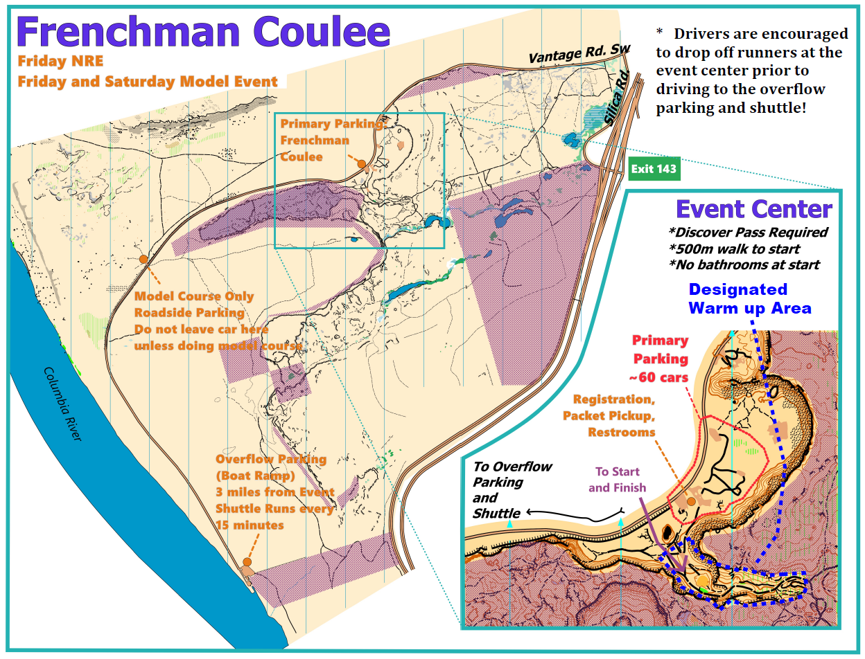
Getting There
This lane reduction is weekdays only in March. More details at WSDOT.
Address / Coordinates:
Event Center
Vantage Rd SW, 2.2 miles West of I-90. (47.02569, -119.96677)
Shuttle Parking
End of Vantage Rd SW at Columbia River boat ramp. (47.0000,-119.9900)
From I-90 Eastbound (From Vantage/Seattle):
- Take Exit 143, East Silica Rd SW
- Turn left (North) on East Silica Rd SW. Continue 0.8 miles.
- Turn left (West) on Vantage Rd SW. Continue about 1.5 miles.
- Watch for orienteering parking signs. This is the event center. Limited parking.
- Continue 3 miles to the end of the road.
- Park in the gravel lot. Take the shuttle to the event center.
From I-90 Westbound (From Quincy/Spokane):
- Take Exit 143, East Silica Rd SW
- Turn right (North) on East Silica Rd SW. Continue 0.8 miles.
- Turn left (West) on Vantage Rd SW. Continue about 1.5 miles.
- Watch for orienteering parking signs. This is the event center. Limited parking.
- Continue 3 miles to the end of the road.
- Park in the gravel lot. Take the shuttle to the event center.