Sunday Classic at Bishop’s Land
Junior Nationals Day 2 - March 24, 2024
8:30am - 9:30am Packet pickup available at the Event Center
9:00am - 11:45am Starts Open. You must be in the start area ready to race 8 minutes before your start time. See your start time on EventReg
2:45pm Courses Close (3hr time limit)
2:45pm* Closing Ceremony and Awards (Sat/Sun races) at Quincy Business & Event Center
Map Information
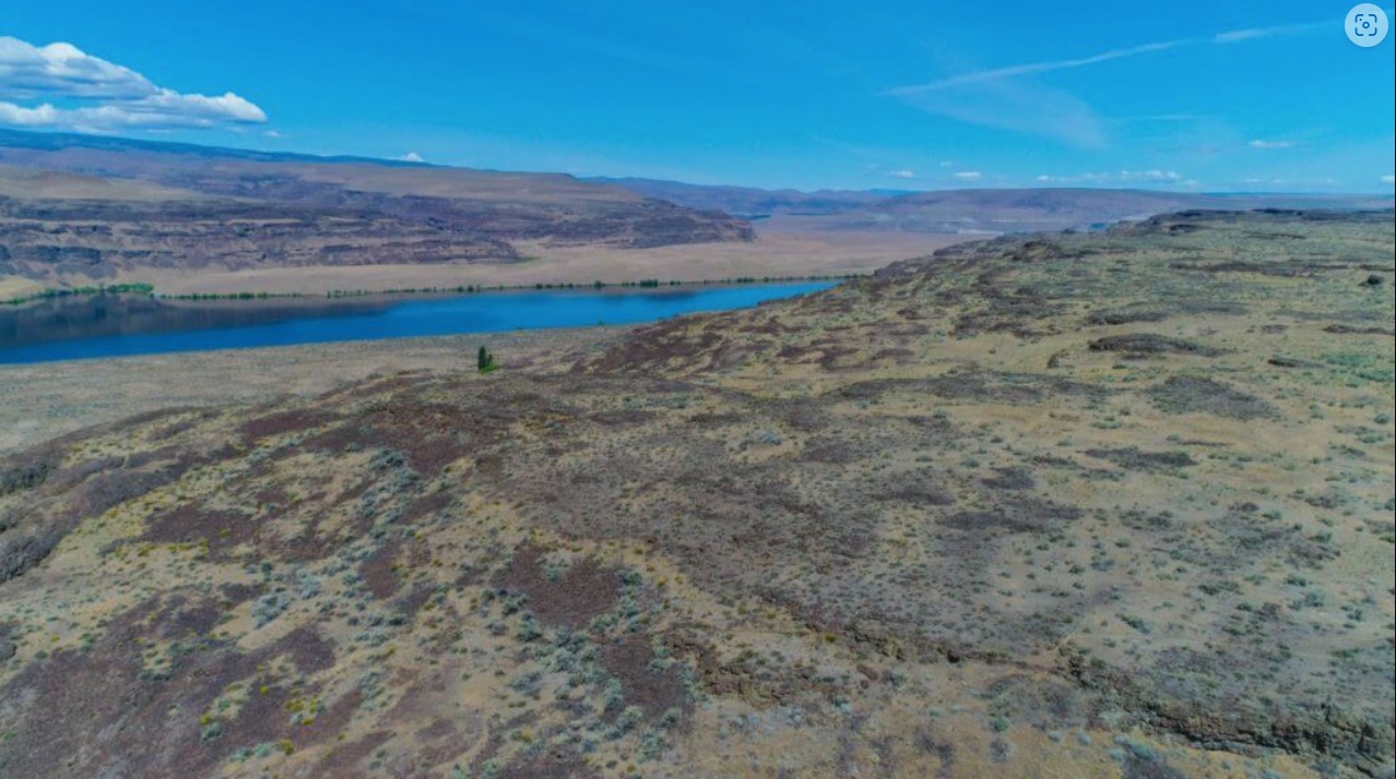
The Bishops Land Recreation Area topography is a direct result of the Glacial Lake Missoula floods. Ancient flood waters poured through the Quincy area and scoured trenches and pools adjacent to the existing Columbia River. These scoured areas have created small buttes and valleys that create a warren of navigable terrain. The area is covered with sage and low-lying vegetation that can obscure smaller point features. However, good contact with the map will provide plenty of attack points and catching features. There are enough roads and trails crossing the east half of the venue to allow for challenges for the younger runners. Due to the seemingly endless channels, courses can provide equal challenges north and south as well as east and west. The venue is a course designer’s dream and a competitor’s welcome challenge.
Download a map of the area used at a previous event: Bishop’s Land - Letter
Reminder that the map shows embargoed areas, and that possession of the map does not imply permission to enter.
-
There are numerous and random animal trails. These are characterized by indistinct paths amongst the sagebrush that appear and disappear and are often difficult to identify from the runners eye level, but will occasionally be noticed. These trails were omitted from the map, unless they were observed to be very distinct and followable.
-
The bare rock symbol and the stony ground symbol are used to describe similar features: high rocky ground, free of vegetation.
-
At Bishops Land, the stony ground symbol was almost universally replaced with the bare rock symbol.
-
At Bishop’s Land, the bare rock symbol is associated with vegetation less ground, typically due to rock formations. The stony ground symbol was not used at Bishop’s Land to indicate high-rocky ground as it was at Frenchman or Quincy Lakes.
Course Notes
Course Designer: Will Enger
Safety Bearing: East to the main dirt road
First, a word on mapping worthy of reiteration - at Bishop’s Land, the 212.0 “Bare rock” symbol has been widely used in a somewhat non-standard way. This symbol does not denote bare rock in the traditional sense of, say, a smooth solid slab of granite or limestone. Rather, it denotes areas where most of the soil has washed or eroded away, leaving footing of somewhat bumpy, finely broken rock with a bit of low grass. These bare rock areas generally occur on the tops of the mesa-like cliff structures, and in real life can be differentiated at a glance from the regular terrain by color, flatness, and lack of vegetation. Thus, they can be a very helpful navigation aid, and usually very runnable. I would recommend checking out the previous version of the Bishop’s Land map available on the event website as well as the Google Maps satellite view of the area to get a sense of how this looks and feels.
Once again, at Bishop’s Land there are many cliffs in the area of all sizes, from less than a meter to the massive cliffs of 100m and more along the western edge of the competition area leading down to the Columbia River. There will be no need for anyone to approach the largest of these cliffs, but in general do be careful at all times - even a short fall can cause serious injury. Always look where you’re going, and know where your next footfall will be. The Orange, Green, Red, and Blue courses will traverse down one particular relatively high and steep slope; the passability of this slope varies from sheer cliff in many places to passable with caution in others. Courses have been set to encourage participants to naturally gravitate toward the safe routes, but even these can feature steep slopes of jagged loose rock, so again please be careful when moving down these slopes. I myself once lost my footing, slipped, and whacked a shin on some rocks while trying to move down a slope too quickly at Bishop’s Land - still the only time I can recall that I’ve failed to complete an orienteering course due to injury.
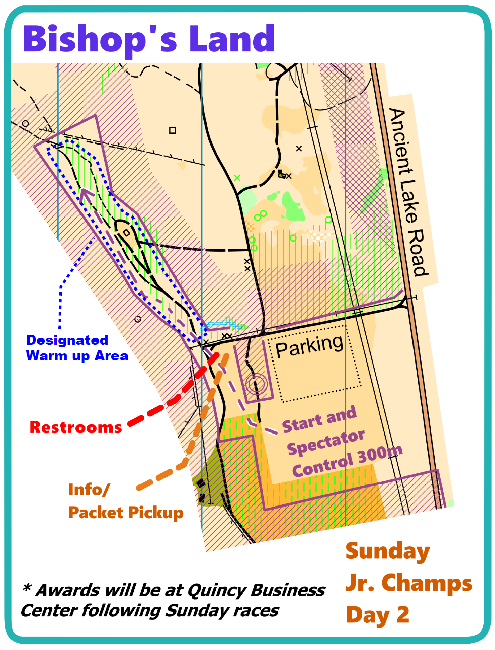
Finally, all participants will visit a spectator/transit control near the end of their course, which will be numbered 108. Everyone will approach this control from points west, and leave it to the east for the final section before the finish. 108 is located along the walk to the start and is meant to be plainly visible to everyone as they pass, so be sure to note and file away its location.
There will be 2-3 legs on the White course which will not be along trails - these legs will have pin flags to guide participants to the next control.
Course Statistics
| Course | Classes | Distance | Climb | Controls | Scale |
|---|---|---|---|---|---|
| White | ISPF, ISPM | F-10, F-12 | M-10, M-12 | M/F-White | Rec White | 1.8 km | 15 m | 10 | 1:7,500 |
| Yellow | ISIF, ISIM | F-14 | M-14 | F-Yellow, M-Yellow | Rec Yellow | 3.0 km | 35 m | 13 | 1:7,500 |
| Orange X | ISJVM, ICJVM | M-16 | M-Orange | | 4.3 km | 115 m | 14 | 1:10,000 |
| Orange Y | ISJVF, ICJVF | F-16 | F-Orange | Rec Orange | 3.9 km | 105 m | 13 | 1:10,000 |
| Brown X | F55+, F60+, F65+ | M65+, M70+, M75+ | F-Brown, M-Brown | 3.7 km | 65 m | 11 | 1:7,500 |
| Brown Y | F70+, F75+, F80+, F85+, F90+ | M80+, M85+, M90+ | Rec Brown | 3.3 km | 50 m | 10 | 1:7,500 |
| Brown Z | ISVF | F-18 | 3.7 km | 65 m | 11 | 1:10,000 |
| Green X | ISVM | M-18, M50+, M55+, M60+ | M-Green | 5.5 km | 135 m | 15 | 1:10,000 |
| Green Y | ICVF | F-20, F35+, F40+, F45+, F50+ | F-Green | Rec Green | 4.9 km | 120 m | 12 | 1:10,000 |
| Red | ICVM | F-21+ | M-20, M35+, M40+, M45+ | M-Red | Rec Red | 7.6 km | 165 m | 18 | 1:10,000 |
| Blue | M-21+ | Rec Blue | 9.4 km | 180 m | 22 | 1:10,000 |
Site Map
Click on the image for a larger version, or click the link to download a pdf version ready to print.
Bishops Land - Site Map - Letter
Getting There
Address / Coordinates:
Ancient Lake Rd, 4.5 miles South of WA 28 (47.1665357,-119.9836198)
From I-90 Eastbound (From Vantage and Seattle):
- Take Exit 149, WA 281 North, Quincy / Wenatchee
- Turn left (North) on WA 281. Continue 5.6 miles.
- Turn left (West) on Rd 5 NW (also signed White Trail Rd). Continue 7.8 miles.
- Turn left (West) on Rd 9 NW. Continue 2 miles.
- Rd 9 NW becomes Ancient Lake Road and turns South. Continue about 3.4 miles.
- Watch for orienteering parking signs
From I-90 Westbound (From Moses Lake and Spokane):
- Take Exit 151, WA 281 North, Quincy / Wenatchee
- Turn right (North) on WA 281. Continue 1.6 miles.
- Turn right (North) on WA 281. Continue 2.9 miles.
- Turn left (West) on Rd 5 NW (also signed White Trail Rd). Continue 7.8 miles.
- Turn left (West) on Rd 9 NW. Continue 2 miles.
- Rd 9 NW becomes Ancient Lake Road and turns South. Continue about 3.4 miles.
- Watch for orienteering parking signs
From WA 28 Eastbound (From Wenatchee):
- Turn right (South/West) on Rd 10 NW. Continue 0.4 miles.
- Turn left (South) on Rd V NW. Continue 1 mile.
- Turn right (West) on Rd 9 NW. Continue 1 mile.
- Rd 9 NW becomes Ancient Lake Road and turns South. Continue about 3.4 miles.
- Watch for orienteering parking signs
From WA 28 Westbound (From Quincy):
- Turn left (South) on Rd U NW / White Trail Rd. Continue 1 mile.
- Turn right (West) on Rd 9 NW. Continue 2 miles.
- Rd 9 NW becomes Ancient Lake Road and turns South. Continue about 3.4 miles.
- Watch for orienteering parking signs