Saturday Classic at Quincy Lakes South
Junior Nationals Day 1 - March 23, 2024
7:00am - 3:00pm Frenchman Spring model course open
8:30am - 11:30am Packet pickup available at the Event Center
9:30am - 12:15pm Starts Open. You must be in the start area ready to race 8 minutes before your start time. See your start time on EventReg
3:15pm Courses Close (3hr time limit)
4:00pm - 5:30pm Junior Social at Quincy Business & Event Center
6:00pm - 8:00pm Welcome Dinner and Friday Awards at Quincy Business & Event Center
Map Information
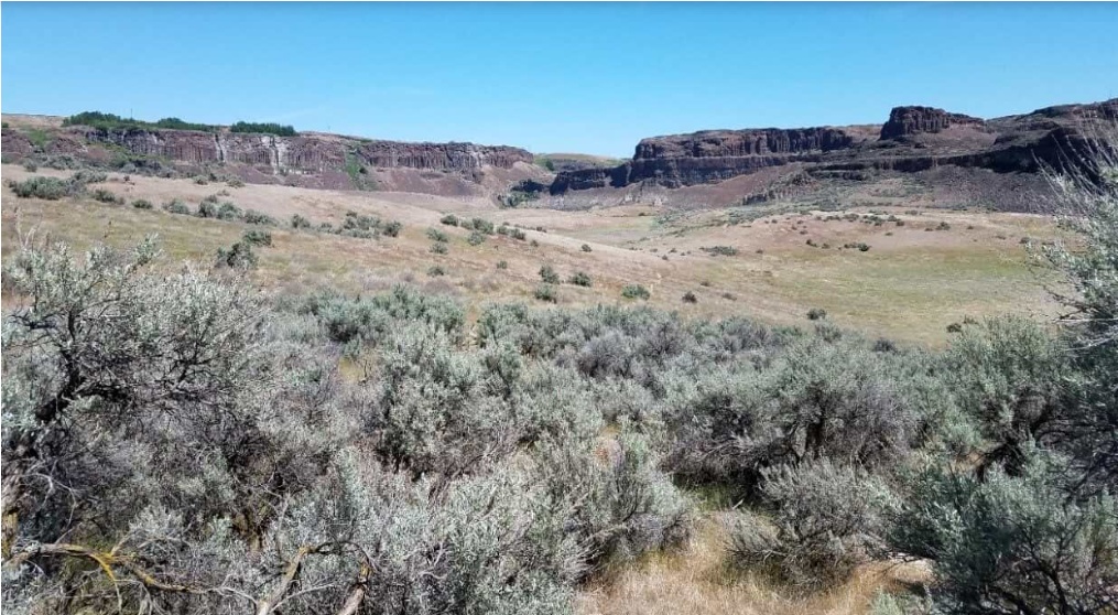
Quincy Lakes is a cross between a series of interconnected water features and a seemingly endless glacially created scab lands. The east portion of the map is inundated with a maze of coulees while the south portion of the map is a relatively flat sage covered plain. The map combines technical and fast paced map reading while traveling from west from the start. Once through the well developed channels and pools runners will encounter terrain where features are subtle and far apart. Runners will need to use compass and a pace count to execute a tight race. While there are fewer trails on this map, younger runners will be able to follow the base of cliffs and run along water features when moving between trails. In addition to the abundant linear features that are numerous subtle point features in the form of depressions.
Download a map of the area used at a previous event: Quincy Lakes South - Tabloid | Quincy Lakes South - Letter - East | Quincy Lakes South - Letter - West
Reminder that the map shows embargoed areas, and that possession of the map does not imply permission to enter.
-
There are numerous and random animal trails. These are characterized by indistinct paths amongst the sagebrush that appear and disappear and are often difficult to identify from the runners eye level, but will occasionally be noticed. These trails were omitted from the map, unless they were observed to be very distinct and followable.
-
The bare rock symbol and the stony ground symbol are used to describe similar features: high rocky ground, free of vegetation. At Quincy Lakes, these areas are typically drawn as stony ground.
-
Stony ground and hills together indicate a volcanic rock-like structure. Similar areas, perhaps with more rock, are depicted with the bare rock symbol.
Course Notes
Course Designer: Will Enger
Safety Bearing: South to the vineyard fields.
As you will have no doubt discovered at Frenchman Coulee on Friday, rock features of all kinds are the predominant theme of these areas. At South Quincy Lakes, rock comes in all shapes and sizes, and is mapped accordingly as cliffs, boulders, knolls, rocky ground, and bare rock - and of course there’s also unmapped rock which is too small or short to make it onto the map. Inevitably not every rock formation fits neatly into one of these categories, so some rocky ground may arguably look like a small cliff, some boulders may also seem like rocky knolls, and so on. Long story short, the main takeaway is that identifying the largest and most prominent rock features along your route and maintaining a wide field of view in this very open and visible landscape will keep you in good stead.
All courses except White will need to cross a fairly steep brushy reentrant shortly out of the start to get to the main part of the mapped area. Two passable crossing points have been marked on the map with the Crossing Point symbol - these have been found to be by far the easiest ways down into and back up out of the reentrant, and it is advisable (but not mandatory) to use them. All courses will come back across that reentrant toward the finish in a different area where a trail exists and the crossing is straightforward.
There will be 2-3 legs on the White course which will not be along trails - these legs will have pin flags to guide participants to the next control.
Course Statistics
| Course | Classes | Distance | Climb | Controls | Scale |
|---|---|---|---|---|---|
| White | ISPF, ISPM | F-10, F-12 | M-10, M-12 | M/F-White | Rec White | 1.8 km | 45 m | 11 | 1:7,500 |
| Yellow | ISIF, ISIM | F-14 | M-14 | F-Yellow, M-Yellow | Rec Yellow | 2.9 km | 65 m | 13 | 1:7,500 |
| Orange X | ISJVM, ICJVM | M-16 | M-Orange | | 4.2 km | 110 m | 13 | 1:10,000 |
| Orange Y | ISJVF, ICJVF | F-16 | F-Orange | Rec Orange | 3.9 km | 105 m | 12 | 1:10,000 |
| Brown X | F55+, F60+, F65+ | M65+, M70+, M75+ | F-Brown, M-Brown | 4.1 km | 125 m | 12 | 1:7,500 |
| Brown Y | F70+, F75+, F80+, F85+, F90+ | M80+, M85+, M90+ | Rec Brown | 3.6 km | 115 m | 11 | 1:7,500 |
| Brown Z | ISVF | F-18 | 4.1 km | 125 m | 12 | 1:10,000 |
| Green X | ISVM | M-18, M50+, M55+, M60+ | M-Green | 5.9 km | 155 m | 17 | 1:10,000 |
| Green Y | ICVF | F-20, F35+, F40+, F45+, F50+ | F-Green | Rec Green | 5.4 km | 145 m | 14 | 1:10,000 |
| Red | ICVM | F-21+ | M-20, M35+, M40+, M45+ | M-Red | Rec Red | 8.4 km | 195 m | 19 | 1:10,000 |
| Blue | M-21+ | Rec Blue | 10.9 km | 230 m | 20 | 1:10,000 |
Site Map
Click on the image for a larger version, or click the link to download a pdf version ready to print.
Quincy Lakes - Site Map - Letter
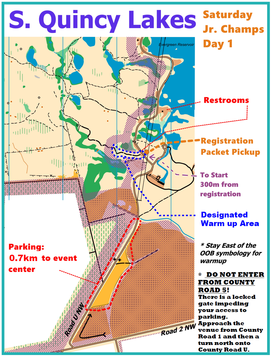
Getting There
Approach from the south using the directions below. There is a locked gate just north of the event center, between registration and the finish. The primary parking area is south of the gate.
Parking for this event is on private land in a field we’ve been given permission to use. A waiver will be required to be signed on site. Parking in the field does not require a Discover Pass. Parking on State DFW owned land does require a Discover Pass.
There is a 700m walk along the road from the parking area to the event center.
Address / Coordinates:
Event Center
Road U NW, 0.75 miles north of Rd 2 NW (47.1253, -119.9347)
From I-90 Eastbound (From Vantage and Seattle):
- Take Exit 143, East Silica Rd SW
- Turn left (North) on East Silica Rd SW. Continue 6.9 miles
- Follow the right turn (East) where Silica Rd NW becomes Rd 1 NW. Continue 2 miles.
- Turn left (North) on Rd U NW. Continue 1 mile.
- Turn left (West) on Rd 2 NW, then immediate right (North/East) on Rd U NW. Continue about 0.5 miles
- Watch for orienteering parking signs.
- Park in the field, walk about 700m North on Rd U to the event center.
From I-90 Westbound (From Moses Lake and Spokane):
- Take Exit 151, WA 281 North, Quincy / Wenatchee
- Turn right (North) on WA 281. Continue 0.1 miles.
- Turn left (South/West) on Rd 1 NW. Continue 1 mile.
- Continue straight (slight left to stay on main paved road) (South/West) on Beverly Burke Rd. Continue 0.6 miles.
- Turn right (North/West) on Rd 1 NW. Continue 3.8 miles.
- Turn right (North) on Rd U NW. Continue 1 mile.
- Turn left (West) on Rd 2 NW, then immediate right (North/East) on Rd U NW. Continue about 0.5 miles
- Watch for orienteering parking signs.
- Park in the field, walk about 700m North on Rd U to the event center.
From WA 28 Eastbound (From Wenatchee):
- Follow WA 28 to Qunicy, then follow directions below.
From Quincy:
- Follow WA 281 South from Quincy for 9.0 miles.
- Turn slight right (South/West) on Beverly Burke Rd. Continue 0.6 miles.
- Turn right (North/West) on Rd 1 NW. Continue 3.8 miles.
- Turn right (North) on Rd U NW. Continue 1 mile.
- Turn left (West) on Rd 2 NW, then immediate right (North/East) on Rd U NW. Continue about 0.5 miles
- Watch for orienteering parking signs.
- Park in the field, walk about 700m North on Rd U to the event center.